Blog originally posted December 11, 2017
At the Archives we work to collect, preserve, and make accessible records that reflect the history of Simcoe County – but that doesn’t mean that all of our materials originate here. One of the most intriguing records maintained by the Archives is a 16th century, European-made map of the American continents.
Officially entitled “Tabula novarum insularum, quas Diversis respectibus Occidentales & Indianas uocant,” but often referred to as “The Münster Map” by SCA staff, the map was created by German cartographer Sebastian Münster (1488-1552). It is considered one of the earliest European depictions of the Americas.
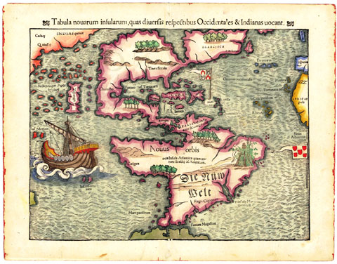
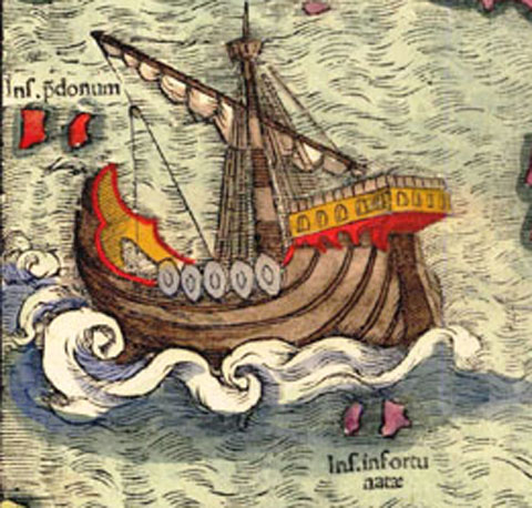
The Münster map was first printed in Ptolemy’s Geographica in 1540, and later included in a very popular German-language atlas entitled Cosmographia, published in 1544.The map was created during a period in European history that has been dubbed the Age of Discovery or Age of Exploration. This period spanned from approximately the mid-15th to mid-16th century. Spurred by increased demand for imported goods and materials from Asia, many European nations were seeking faster, alternate trade routes to the east. For a time it is was believed that a western route across the Atlantic Ocean could be established. The exploratory voyage of Portuguese navigator Ferdinand Magellan from 1519-1920 went a significance distance to dispelling the belief that a direct route across the Atlantic was possible. Magellan’s influence is clear on the Münster Map: Not only does it feature Magellan’s Strait, but Münster also included an illustration of Magellan’s ship the Victoria.
Another notable feature of the map is the inclusion of the false Sea of Verrazzano. The Sea of Verrazzano was believed by European cartographers, at one point, to be a navigable Northwestern passage to Asia. By the time Münster set out to create his map, Europeans had a slightly better grasp on the size and magnitude of the American continents – although the myth of the false sea persisted.
The Münster map was donated to the Simcoe County Archives by Norman Dwight Clarke (1893-1977) in 1976. It is now part of the cartographic series in the Norman D. Clarke Collection.
Works consulted
- Schwartz, Seymour I. (2008). The Mismapping of America. Rochester, NY: University Rochester Press. Pg. 56.
- The Editors of the Encyclopedia Britannica. (2017). The Age of Discovery. Retrieved from https://www.britannica.com/topic/European-exploration/The-Age-of-Discovery